Mounts Abraham and Ellen
Submitted by Pat
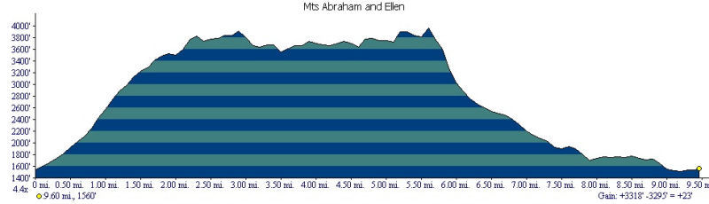
Stats
Mountains: Mts. Ellen (4,083) and Abraham (4,006)
Date: November 3, 2006
Time: 10 hours and 53 minutes
Weather: Mostly cloudy, occasional sun, calm, temps ranging 20's-30's
Miles: 10.9
Elevation Gain: 3,318
Steps: 38,054
Trails: Battell Trail to Long Trail to Jerusalem Trail
Holy Shit Factor: Very high
Picture Gallery
The plan is to climb Mounts Ellen and Abraham on Friday and Mount Mansfield on Saturday. After breakfast in Burlington we head in two cars to the Jerusalem trailhead where we drop off Nancy's car. We are lucky to find it since the turn off for Jim Dwyer Rd. is obscured by a pine tree and the trail marker by the road is very small. Nancy piles into my car and we drive to the Battell Trail. As we approach the trailhead we can see Mt Abraham and the ridge covered in snow. I ams beyond myself with excitement.
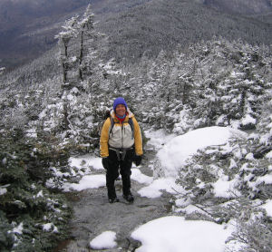 We gear up - Nancy puts on her new winter hiking boots (including chemical foot warmers), 3 layers, plus gloves with chemical hand warmers. Temperature is so deceiving when standing around gearing up at the trailhead. It feels cold so the natural inclination is to dress warmly. It's hard to remember and believe that we need to dress down a layer or two because as soon as we start climbing we will be generating our own internal heat. This is only our second 4,000 footer in colder/snowy conditions and we are still learning the ropes. We leave the trailhead at 8:53 am and head into the woods. We gear up - Nancy puts on her new winter hiking boots (including chemical foot warmers), 3 layers, plus gloves with chemical hand warmers. Temperature is so deceiving when standing around gearing up at the trailhead. It feels cold so the natural inclination is to dress warmly. It's hard to remember and believe that we need to dress down a layer or two because as soon as we start climbing we will be generating our own internal heat. This is only our second 4,000 footer in colder/snowy conditions and we are still learning the ropes. We leave the trailhead at 8:53 am and head into the woods.
It doesn't take long for Nancy to warm up and start sweating. Off come the boots, out come the chemical hand warmers, and a layer. She puts on her light hiking boots and off we go. After about a half hour of walking we see our first traces of snow. The lower part of the trail is switch backed and pretty gentle. We haven't hiked since October 21 and it's amazing how fast we lose our aerobic conditioning. I am huffing and puffing as we reach the steeper sections.
We arrive at the Long Trail at 10:30 a.m. and start gaining elevation immediately. The snow deepens and once we move into the coniferous forest, it looks like a winter wonderland. The temperature begins to drop, the snow to deepen, and there is more ice since the path is wet. Before we reach the ridge we stop so Nancy can change out of her wet clothes into dry and to put on stabilicers and gaiters. The view from where I am standing is impressive. I am a little higher up the trail and watch Nancy get herself changed. I don't notice, however, that while she is putting on gaiters and stabilicers that her hands are getting colder and colder, to the point that when she tries to pull on dry mittens, she is unable to grasp the chemical warmers to put them in the gloves. I come down the slope a bit and offer to help. She says she can't feel her fingers and I can see she doesn't have the dexterity to pull on her mittens. I help her get them on and once we start moving again, she regains sensation and we are good to go. 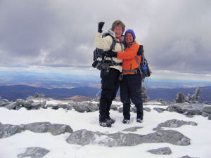
Unfortunately, where we changed clothes is not as close to the summit as we had hoped so new sweat is generated and Nancy has to take off her hard shell and put on a light wind breaker. We reach the summit of Mt. Abraham (elevation 4,006) at 11:42 a.m. The wind is blowing so we take a quick picture and move on. At this point I realize this is going to be a very long day and that we will not get off the trail before dark. I don't feel particularly anxious - just facing facts.
We reach Lincoln Peak and come off the trail at the top of a ski area. I think it is part of the Sugar Bush Ski Area. The Long Trail Guide is not very verbose in describing trail locations but we find a blaze off to the left and see a post but no sign. A few minutes later we come out on a ski trail and see no sign of the trail on the opposite side. The guide is not helpful at this point and nothing obvious is visible. Just a lot of snow. We start walking down the ski slope but that doesn't feel right and I start to get frustrated and a little angry. In fact, the anger fuels my legs so that I storm back up the slope hoping to see something that will help locate the trail again. I don't see a trail, but I do see signs of skiers having arrived at the hut so I knock on the door. Fours guys are in there warming up and eating power bars. I ask directions and they tell us to go back down the ski slope and bear left before the slope actually starts down to the right. Yeah, right. They ask where we are headed and are impressed that we are doing a day hike. I wonder what they really think.
 We start back down the slope, postholing and slugging through two feet of snow. I am still angry and frustrated by the poor trail marking - and maybe just a bit anxious. When we come to the bend in the ski slope we bear left, hoping we are on the trail, not seeing any blazes. Shortly thereafter we intersect the real trail and are on our way again. My anger cools and I regain my good humor. We reach Nancy Hanks Peak at 1:54 p.m. The snow depth on the ridge ranges from a few inches where there are lots of overhanging pine boughs to 18-20 inches where there is nothing. We keep our stabilicers on because there is a lot of ice under the new snow. We start back down the slope, postholing and slugging through two feet of snow. I am still angry and frustrated by the poor trail marking - and maybe just a bit anxious. When we come to the bend in the ski slope we bear left, hoping we are on the trail, not seeing any blazes. Shortly thereafter we intersect the real trail and are on our way again. My anger cools and I regain my good humor. We reach Nancy Hanks Peak at 1:54 p.m. The snow depth on the ridge ranges from a few inches where there are lots of overhanging pine boughs to 18-20 inches where there is nothing. We keep our stabilicers on because there is a lot of ice under the new snow.
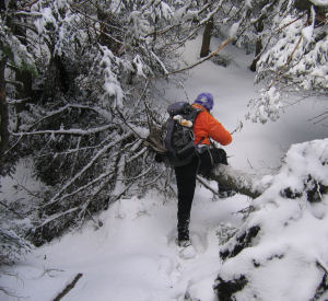
Blow downs become our nemesis - lots of them - maybe 6-10 areas where trees have fallen from last weekend's wind storms. The amount of additional energy it takes to find a way around or over them starts to take its toll after an hour or two of dealing with this. We have been eating power bars through the morning because we did not bring any lunch food per se. Not a smart decision in retrospect. At the last minute I bought a bagel and that really helped me because I can only eat power bars for so long before my stomach wants simple carbs, not sugar and protein. Of course our hydration packs froze so we manage with our Nalgene bottles. I just drink less when I have to stop and drink rather than drink as I walk. The temps are such that the power bars in pockets on the outside of my pack are starting to freeze but the bagel that is inside my pack does not. What do you bring on a long winter hike to eat that won't freeze?
We start hearing this strange whooshing noise as we get closer to Ellen. I think it is the sounds the ski lift wires make as they grind against the pulleys. We arrive at the summit of Mt. Ellen (elevation 4,083) at 3:04 p.m. At that point we know we have a couple more miles to go on the ridge and 2.5 miles on the Jerusalem Trail. Oh my. A picture and a high five to celebrate our 38th peak and we push onward. We come out at the top of another ski area. The sound we heard is the sound of snow guns. There is no sign of anyone around. A sign points a sharp left for the trail. We walk down the slope and pass a wooden barrier until we look at each other and realize we are lost again. Nancy re-reads the guide info and it states that the trail turns off the slope to the left about 100 feet from where the other trail enters and begins a steep descent. We walk up and down the slope trying to find a blaze, an opening that looks like a trail, anything. Again, I grow frustrated and work hard to remain calm. I try a couple of places that look like openings and finally guess right and find the trail. No sign, no blaze, and the trail is so overgrown it is all but invisible. It is a while before we see a blaze and know we are on the right track. What a relief!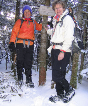
For the next hour we hike the overgrown trail. It is hard to follow - the white blazes are old and difficult to see and branches have grown over the trail. We are constantly dealing with snow showers down our necks. Around 4:30 we stop - Nancy changes her outer layer and puts on a dry soft shell and we both put on our Petzel Tikka Plus headlamps - and start walking again. As the daylight is leeched from the sky, we can see Lake Champlain and the lights of Burlington beckoning to our left. But we are hours away and it is best not to stop and rest for too long since starting up is getting harder and harder for me. My knees and feet are starting their usual moaning and groaning. I can also feel the strain on my upper body since I used my poles for most of the hike. Time to get in the gym and work those triceps and core muscles.
Once it is true dark, I am anxious about seeing the trail marker for the Jerusalem Trail, if there is a sign at all. A lot of energy is spent moving my head left and right looking for a sign. At 5:34 p.m. we breathe a sigh of relief when we find the sign for the Jerusalem Trail. Everything is downhill from there. The first tenth of a mile is really steep so it is slow going. The lights work extremely well. I feel like a ray of light in a cocoon of darkness. There is nothing to distract me, just the few feet in front of me, and the occasional sweep of the light to try and find the next blue blaze. Luckily the Jerusalem Trail is well blazed and every blaze is like a special gift - a treat, a sense of safety and belonging, a feeling that I know where I am.
About an hour into the descent, I make an error and lead us to the left down an old logging road. Something feels wrong - there are no blazes. Nancy reads the trail description but it is more confusing than helpful. We stop to take our stabilicers off since they are just picking up soft snow and making walking even more difficult. I suggest that I walk back to the last blaze but Nancy says, no, we should stick together, so together we start back. I think the walk back to the last blaze is going to take forever, but it doesn't and we quickly find the blaze leading us back to the real trail. Phew.
It is a long walk to reach the trailhead at 7:44 p.m., but we make it. It is a great day - full of adventure and lessons learned. But I am done. My body is finished. I can feel muscles and tendons tightening up and I know I am going to be in some pain. We get back to Burlington a little before 9 p.m. and after dinner and a shower we lay in bed talking about the day and wondering at how tired we are but feel completely unable to sleep. Our overtired bodies finally let us go a little after midnight. We decide that Mansfield is going to have to wait for another day. It is a good decision.
38 out of 67 NE 4,000-Footers
39 out of 100 Highest
| 
