Straight Up Wildcat
Submitted by Nancy
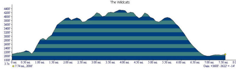
Stats
Mountains: Wildcat D (4,050) and Wildcat (4,422)
Date: November 18, 2006
Time: 10 hours and 15 minutes
Weather: Sunny and clear, clouds roll in briefly at dusk
Miles: 12.95 by my pedometer, but we figure around 10.75
Elevation Gain: 3,608
Steps: 39,924
Trails: Lost Pond Trail, Wildcat Ridge Trail, Polecat Ski Trail, and Rte. 16
Holy Shit Factor: Right the hell up there
Picture Gallery
Short Video Clips
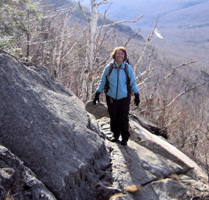
Nancy on the ledges
View from Wildcat A
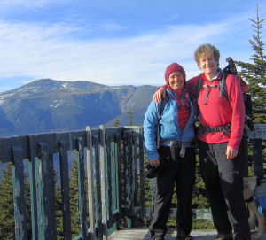
High Five for #40
 The plan is to hike Middle and South Carter. We leave Keene at 5:30 a.m. and arrive in Pinkham Notch around 9. As we near the Notch, I suggest we hike Wildcat instead. The trailhead is closer and the hike is shorter - 10.4 miles out-and-back compared to Carter's 12.4 loop. We are getting a late start, so a shorter hike feels more prudent. BUT we are prepared for the Carters and do not know what the Wildcats have in store for us. The plan is to hike Middle and South Carter. We leave Keene at 5:30 a.m. and arrive in Pinkham Notch around 9. As we near the Notch, I suggest we hike Wildcat instead. The trailhead is closer and the hike is shorter - 10.4 miles out-and-back compared to Carter's 12.4 loop. We are getting a late start, so a shorter hike feels more prudent. BUT we are prepared for the Carters and do not know what the Wildcats have in store for us.
We park at the Pinkham Notch Visitor's Center and at 9:20 a.m. start off on the Long Pond Trail to avoid crossing the Ellis River, which proves way smart. Of course - we are way smart girls! We would have had to take off our boots AND pants to cross and that would not have been pretty. From there we hit the Wildcat Ridge Trail and up we go. Yes, up. Straight up. The 4,000 Footer book by Smith and Dickerman calls the Wildcat Ridge Trail "an exceptionally steep rugged climb up." You got that right, boys! The highway stayed just below us as we hiked up and up and up. Nothing gradual about this trail. NOTHING! The views of Washington are beautiful and we stop frequently to marvel at the Presidentials while sucking big wind. The trail is littered with the fairy dust of mountains, mica.
There are a number of ledges and very steep tricky climbs. Dejah is with us -- my daughter's almost 2-year-old yellow lab and my trail dog. (Dejah was wearing her new dog pack which had a couple of extra Nalgene bottles of water, just in case. So she is getting used to a) more weight and b) having a wider girth so she struggles with some of the tight squeezes and pitches that require a hefty jump up.) Once we get to the tricky ledges, she starts to cry. She sounds scared and desperate. We encourage her, show her the way, and give her a nudge here and a slight push there. When she finally gets so scared we will go on without her, she easily jumps to the next ledge and up we all go. At the summit she is wagging her tail, happy as can be, having forgotten the difficulty she experienced getting here. Meanwhile, I have not forgotten my difficulty in getting here, and I'm not sure about Pat - but I can remind her! You know how some hikes come easy and some don't? Well, I can tell this is going to be in the "not so easy" category. I just don't feel like me. Onward... 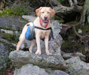
At 12:17 p.m., we arrive on the summit of Wildcat E (4046 feet) - which I understand was FORMALLY a 4,000 footer according to Smith and Dickerman (OK - what does that mean -- a FORMER 4,000 footer? What? E died? E shrank? E doesn't cut the mustard? What?) We take a moment to re-assess. Both Pat and I are worried about going back down the Wildcat Ridge Trail in the dark with Dejah. I have visions of her flying off the side of the mountain, or me falling off the ledge, which sends chills down my spine. We talk about our options and decide on one alternative which is to go down the Nineteen-Mile Brook Trail from Wildcat A and hitchhike the 4-5 miles back to our car. Sure, yeah, someone will pick up 2 smelly backpackers and a muddy DOG! Yeah that'll work - good plan! OK - not a great plan, but a plan nevertheless. We climb past the gondola station in the Wildcat Ski Area to the summit of Wildcat D (4062 feet) at 1:15 p.m. for our high five celebration of bagging #39.
On the way down from D we meet a couple of hikers (the only people we see all day) who tell us that the roughest and most difficult part of the trail lies ahead (thanks, dude) and that the best way down is to take the Polecat Ski Trail from the gondola station down to the Wildcat ski area parking lot, only a mile from our car. They say it is gradual and well packed down because lots of hikers and ATVs use the trail. Ahhhh - that's the ticket. Now we have a feasible plan.
 OK - could we have come up with slightly more creative names than Wildcat A, B, C, D and E? It sounds like a Kindergarten children's book - and there is nothing Kindergarten about the Wildcats! I mean c'mon now! How about using other animals? Wild Fox, Wild Emus, Wild Kanga, Wild Porcupine - whatever man! Or stick to the cat family - there's a lot to choose from -- cheetah, jaguar, leopard, lion, tiger, cougar, panther or bobcat. Or we could name the peaks what they deserve - Mt. Hell-Of-A-Climb, Sucking Wind Mountain, Mt. O Holy Shit, Mt. What-the-Fuck and Straight Up Mountain. Anything but A, B, C, D, and E! OK - could we have come up with slightly more creative names than Wildcat A, B, C, D and E? It sounds like a Kindergarten children's book - and there is nothing Kindergarten about the Wildcats! I mean c'mon now! How about using other animals? Wild Fox, Wild Emus, Wild Kanga, Wild Porcupine - whatever man! Or stick to the cat family - there's a lot to choose from -- cheetah, jaguar, leopard, lion, tiger, cougar, panther or bobcat. Or we could name the peaks what they deserve - Mt. Hell-Of-A-Climb, Sucking Wind Mountain, Mt. O Holy Shit, Mt. What-the-Fuck and Straight Up Mountain. Anything but A, B, C, D, and E!
And while I'm pissing and moaning - how about a few signs? Without signs on a ridge with 5 peaks it's a bit difficult to figure out where we are. We go down, in this case straight down, and then we go up, in this case straight up. At the point where we are about to descend again I think this must be a peak. Let's call it C. We start down again and then straight back up again and when we reach what feels like the height of land I figure we are on B. Of course it could be C. This continues ad nauseum until I have absolutely no idea if we have summited C, or B, and, oh by the way, where the hell is A? As we hike, we continue to see the next mountain ahead of us in the distance. Each time I mutter a "Oh Holy Shit, is that where we're going?" We do another up and down and I am hoping we are on A - but no - we don't think so, the trail continues, so that must be B, but it could be C. We go down and back up - maybe this is A? No? B? C? C'mon - a sign would help, folks! We eat lunch somewhere along the ridge - I have no idea where. Thankfully, Pat has read that you can see Carter Notch and the hut from the summit of Wildcat A. Thank God there it is. We are on A (4422 feet). We bag #40 at 3:30 p.m. Now, no problem - we just have to go all the way back! 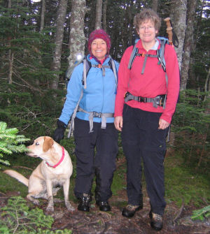
We retrace our steps along the muddy ridge, going sharply up and down and up and down and up and down - I don't even try to figure out what peak we are on. About halfway along the ridge, at dusk, we stop to put on our headlamps. The mica sprinkles along the trail, reflecting the light from our headlamps, glittering all the way back, making the trail look luminous, almost magical. Finally, after what feels like forever to me, we get to the Wildcat Ski Area at 5:32 p.m. and begin looking for the Polecat Trail. At this point it is pitch dark and clouds are rolling over the summit considerably limiting our visibility. I say considerably because that sounds like what I should say in a hike report - but what I really mean is we couldn't see shit! How are we supposed to find the trail if we can't see more than 20-25 feet in front of us? It feels surreal up there and totally disorienting. As we search for the trail marker, we see a pair of green eyes looking back at us and hear a strange high-pitched noise. Yo, Pat, we've got company. We don't know what it is but he definitely spooks us.
We can't find the trail and can only see the gondola station so we decide to hike down underneath the gondola cables, walking from pillar to pillar, thinking we might be able to see one to the next. WRONG! We start down and immediately find ourselves on jagged rocks and in the bushes. We can't see the next pillar and we can't clearly see what we are walking on - we just know it isn't feeling good. At this point I have a flashback. I am a kid skiing. Riding up on the chair lift, often the ski trail is right below us and we try and spit on the skiers (nice huh? - I promise I've grown up to be a decent human being but I had my moments as a kid). But often the trail disappears and we are looking down at ledges and rock cliffs below us. I'm thinking that following the gondola down might not be such a good idea. We decide to try and find the ski trail and hike back up to the summit. Sure my quads have a little bit left...NOT!
Pat finds a trail and down we go. AHHHH, this feels much better! We are on smooth ground, heading down and can just barely make out ATV tracks in front of us. We are on the trail! YES! As we descend, our knees start talking to us...loudly. We are both done and announce it with feeling. The trail, however is not done, but continues down for 2 3/4 miles! Dejah seems happy; her knees don't seem to be talking to her. As we descend the clouds clear and the night emerges in front of us, thousands of stars light the way, with the Big Dipper directly in front of us. We turn off our headlamps and gaze up at the starry sky, reorienting ourselves, letting the calm of the night in. We breathe.
We reach the ski area parking lot at 7:15 and walk the last veeeerrrrryyyyy looooooonng mile on Route 16 back to our car. We get to the car at 7:35 p.m. and head home. Whoooo Hooooo!
35 of NH 48
40 of 67 in NE
41 of the NE 100 Highest
|